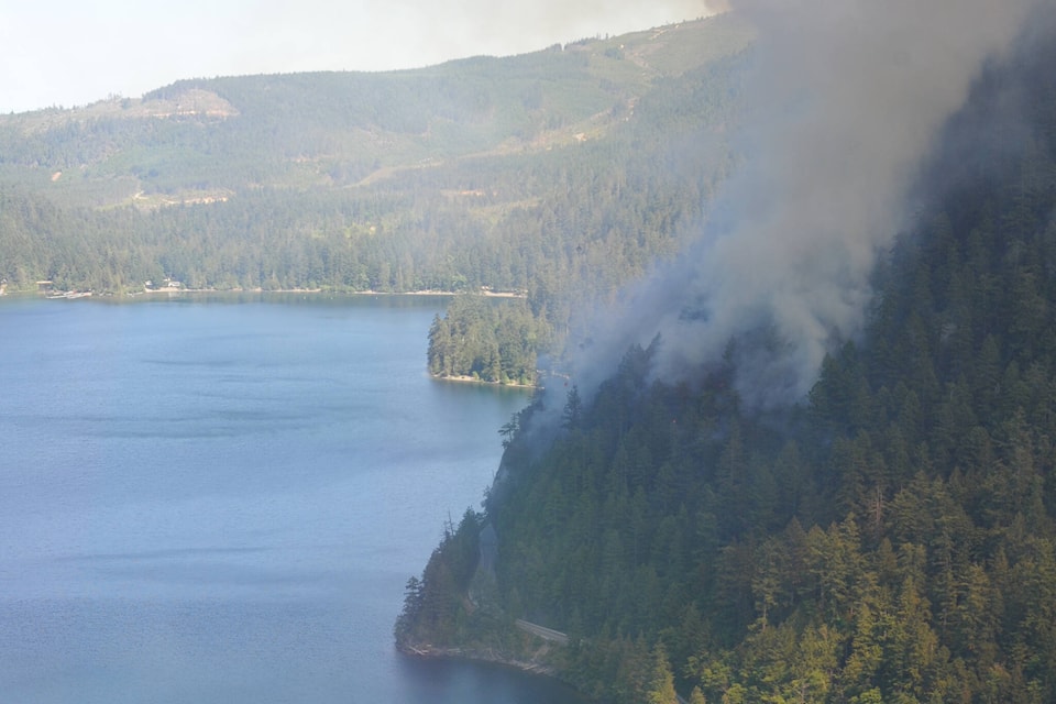
A wildfire burning east of Port Alberni is now listed at 254 hectares, despite recent rainfall.
The Cameron Bluffs wildfire, which is burning in steep terrain near Angel Rock above Highway 4, has been burning since Saturday, June 3. The area received 15 mm of rain on June 9, but BC Wildfire says the precipitation was not enough to “significantly” impact the drought within the Coastal Fire Centre.
“Cooler temperatures and higher relative humidity are helping crews action the fire and work on containment lines on all flanks,” said a BC Wildfire spokesperson. “Fire behavior is decreased and is currently displaying a smoldering ground fire with some open flame.”
The size of the fire increased from 209 hectares to 254 hectares, but the Alberni-Clayoquot Regional District’s (ACRD) emergency program says this increase “is not reflective of fire growth, but rather better mapping of the affected area.”
According to BC Wildfire, there has not been “notable growth” on the fire to the east or west—most of the growth has been on the southern flank, which is upslope and away from Highway 4.
Ground crews are currently working on the west flank of the fire, which is the flank closest to Cathedral Grove, and the north flank of the fire, which is closest to Highway 4. Helicopters are helping crews work on hot spots of the fire on the eastern flank, which is closest to communities around Cameron Lake. The fire does not pose any immediate threat to homes at this time, and there are no evacuation orders or alerts in place.
Highway 4 remains closed for an indefinite amount of time, although BC Wildfire’s Incident Management Team says it is working with the Ministry of Transportation and Infrastructure to make the highway corridor safe for travel.
A detour route is available between Lake Cowichan and Port Alberni via Bamfield Main, but people are being asked to use the road for essential travel only.
READ MORE: Pilot cars to escort convoys of food, fuel trucks around Highway 4 detour
Starting Sunday, June 11, piloted convoys specifically for commercial vehicles will be guided daily along the detour route to and from Port Alberni. Other drivers will be put behind the convoys because the priority is to move essential supplies, according to the transportation ministry.
There are no other routes available around the Highway 4 closure, as the Horne Lake connector to the north is reserved for emergency vehicles and B.C. Wildfire Service personnel.
elena.rardon@albernivalleynews.com
Like us on Facebook and follow us on Twitter