It’s no secret the Comox Valley is a photographer’s paradise, but those taking to the air are paying heightened attention to what shouldn’t be in the skies near them: drones.
For pilots - private, commercial and military - drones increasingly have become an issue during flight, particularly since most of the area in the Comox Valley prohibits the use of recreational drones.
“Drones have become a big issue within the last couple of years,” explained Capt. Blake McNaughton, advance and safety pilot for the Canadian Forces Snowbird team to media. “Most people who use recreational drones don’t even know the rules that govern (them).”
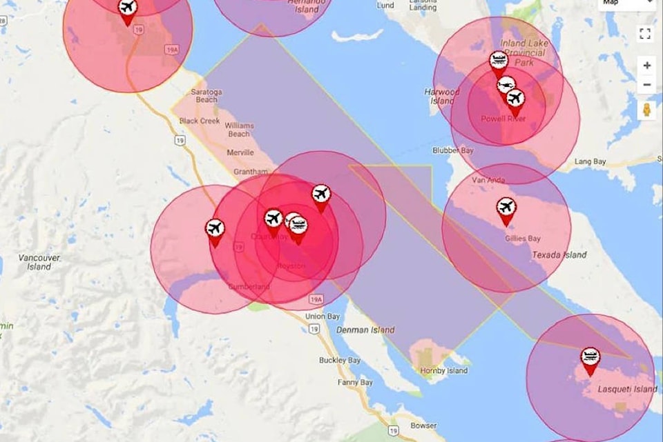
Drones are regulated by Transport Canada, which recently released new rules for recreational users. For drones that weigh more than 250 grams and up to 35 kilograms, some of the regulations include that they must be flown to a maximum of 90 metres above the ground, only during the day, not in clouds, within 500m of the operator and at least 5.5 km from aerodromes (any airport, seaplane base or areas where aircraft take off and land).
Due to the latter regulation, it is essentially illegal to fly a drone within the Comox Valley, added McNaughton.
“Especially during the Snowbird performance, those drones can cause conflicts very much like a bird that can impact the airplane and cause significant damage. We try to avoid interacting with drones as much as possible, and if we see them, unfortunately, we have to pause our show until they can be grounded and moved out of the restricted airspace.”
Due to Smit Field off Forbidden Plateau Road, the Courtenay Airpark and the Comox Airport, recreational drones are forbidden to be flown anywhere between Union Bay and Saratoga Beach, or anywhere east of Comox Lake.
For those who operate drones for survey, agricultural or police work and inspections, academic research or aerial photography for real estate, a special flight operations certificate can be obtained through Transport Canada.
If flown in a restricted area without permission, users can be fined up to $3,000.
Fred Bigelow, CEO of the Comox Valley Airport said while there has not been an incident with a drone and a commercial aircraft at the airport, drones could easily cause a collision with an aircraft if flown nearby.
“There’s times when a bird gets ingested into a jet engine, and it could lead to a catastrophic accidents … it could be very similar to that.”
Licenced drone operator and owner of RicksKopter.com Rick Ward has been flying drones since 2012 and has been flying commercially for three years.
He said it’s easy for consumers to walk into a store and purchase a recreational drone, but they don’t necessarily realize the rules in place.
“There’s so many regulations and so many different things you need to know about them,” he noted to media.
“I just think right now people are learning about the regulations … just don’t fly too close to people’s property and be respectful people wherever - walking, vehicles - keep a good distance away from vessels and buildings and fly safe.”
Some new drones have software built in which restricts them from flying into certain areas automatically, he added.
But Capt. Graham Edwards, 19 Wing Flight Safety Officer, noted in an emailed statement that drone operators need to be aware that in many cases, software and instructions included with drones do not accurately depict all the restricted areas, do not show helipads, seaplane bases, controlled airspaces or national parks.
“Where restricted areas are shown, it’s important to note that often, the manufacturer’s software also applies much smaller distance restrictions than Transport Canada,” he added.
For more information and to view an interactive map of the restricted zones, visit tc.gc.ca/eng/civiilaviation/drone-safety.html