Within 60 seconds of the new Geoscience BC Minerals Project covering Northern Vancouver Island being released, the first claim had been staked.
The speed with which that claim was staked could be attributed to both the new digital based staking process and the depth and breadth of Geoscience BC’s report.
Presenting to a packed room and hosted by the Port McNeill & District Chamber of Commerce, Geoscience BC held an open house in Port McNeill on Feb. 18 to announce the results from last summer’s mineral survey of northern Vancouver Island.
Speaking at the presentation, Richard Truman, Director, External Relations at Geoscience BC explained how the goal of the not for profit organization was to accelerate and capitalize the economic opportunities for our region.
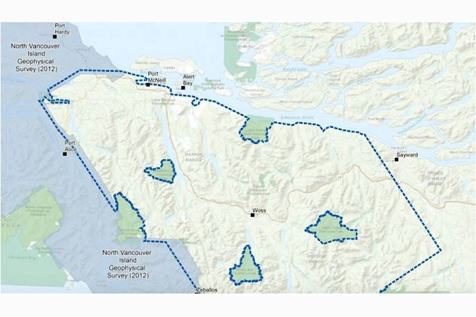
To assist in achieving those outcomes, their Northern Vancouver Island Minerals Project undertook an aerial survey last summer that covered over 6,000 square kilometres, stretching between Port McNeill in the north and Tahsis in the southwest. The landmass covered represented approximately 20 per cent of the total area of the Island.
Vancouver Island has a long history of mining and mineral exploration but according to Geoscience BC, there are still areas on the northern Island that remain relatively under-explored. Truman explained how the project was designed to provide current and unbiased information to help in exploration and aid in the development of those resources.
In order to facilitate that growth, Geoscience BC felt it was necessary to provide new and reliable research data along with updated geological maps that would help identify areas where mineral exploration may lead to new mines and provide economic benefits to communities here on the North Island.
Cost for the project was $1.1 million and Truman estimates that for every dollar invested in the project, six dollars in new exploration investment will be returned to the region.
In the first 15 days following the report, a total of 34 new claims were staked within the survey region.
Geoscience BC feels, “The information generated by this project may spark a new wave of mineral exploration activity in this region.” The information is available to the public and, according to Geoscience BC, “should help the exploration sector, communities, Indigenous groups and governments make informed decisions about responsible natural resource development.”
Industry experts agree, says Greg Neeld, President & CEO, Hawkeye Gold and Diamond Inc, explaining: “This vital information will be key to new mineral exploration and potential discovery creating economic benefits to communities…”
Dallas Smith, President, Nanwakolas Council Board of Directors echoed Neeld’s confidence, adding: “Public geoscience data will bring new mineral exploration interest and investment to the Island.”
And Kendra Johnston, President & CEO, AME (Association for Mineral Exploration) feels the data from this project will be of benefit and used by grassroots prospectors all the way through to multinational mining corporations.
Geoscience BC is an independent, not for profit, public geoscience research society that gathers and provides to the public, data about British Columbia’s minerals, energy and water resources. Geoscience BC feels this in turn advances knowledge, informs responsible development, encourages investment and stimulates innovation.
For more information or to view the reports, visit www.georscienbc.com
- Bill McQuarrie article