Bute Inlet, located north of Campbell River on the mainland coast, is looking a little bit different after a glacial lake burst causing a damaging wave to rush down the river into the fjord.
According to the co-director for the Centre for Natural Hazards Research at Simon Fraser University Brent Ward, at around 6 a.m. on Nov. 28, a landslide occurred near a glacier in the Coast Mountains of southwestern B.C.
“There was a landslide from the west side of the valley that hit the front of the glacier then turned a corner and went into the lake. It triggered a very large wave,” Ward said. “People have looked at it, and they figure the wave was at least 70 metres high and possibly higher. It could have been up to 100 or 110 metres. That would have triggered a wave that travelled down the lake, which would have over-topped where the river exits the lake and started down it… The creek started to down-cut. Then once you do that, all of the water that’s in the lake continues to drain out. It was a huge event, a huge amount of sediment eroded out of that valley and deposited on the fan and then finer sediments went down the Southgate River and into the fjord.”
Story continues below…
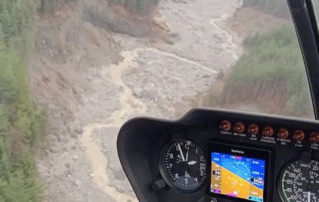
A Campbell River-based helicopter tourism company heard about the incident, and sent a pilot up the inlet to investigate. The video he took shows that was once just a regular creek turned into a raging river that wiped out thousands of trees and carved a deep gash down the centre of the valley.
“There’s been a few reports in the last week that there were lots of floods in Bute Inlet, so we went to check it out. It was coming from a landslide that happened in the Southgate River in the inlet. It’s a huge one, it’s a massive one,” said pilot Bastian Fleury. “I’ve seen landslides, but that’s the biggest one I’ve seen and the biggest one that’s happened around here in the last few years for sure. We followed the landslide up, it’s about 10-12 km long. At the top there’s a glacier, and the glacier is different too. It lost lots of ice that ended up in the lake, which created a wave that probably flooded the valley.”
“I know the spot, I’ve flown there before and it’s totally changed now. It’s really wide, flooded the whole Southgate River,” he added.
The massive rush of sediment into the valley will have a large effect on the fish population that uses the rivers affected as spawning grounds, Ward explained.
“The river itself will start to modify the sediments, but it’s going to have a serious effect on fish. The lower reaches of Elliot Creek are Coho habitat, and if you look at those images, that habitat is now buried with gravel. I think there’s a Chum run that goes up the Southgate, and that may be better off because the river will probably re-establish, but if there were any fry or eggs in that lower part of the channel then it would have been affected,” he said.
“It’ll come back, these landslides happen, but when you’re dealing with a four-year life cycle of a fish, it’s going to have a longer effect than that. So Elliot Creek will start to cut channels into the fan, and those lower reaches will start to cut back, but it’ll take a while,” he added.
These kinds of events are not unheard of, but they are relatively rare. Thankfully, Ward said, there have not been any recently in Canada that have caused any injuries or deaths, but those kinds of landslides do happen elsewhere in the world.
“We’ve been very very lucky that no one has been killed,” he said. “In other parts of the world where these things happen in higher population densities, they’ve killed a lot of people, especially in the Himalayas. There was a big event at Chehalis Lake back in the 90s that wiped out three campgrounds, but luckily there had been a whole bunch of snow, so nobody was there.”
Ward said the extent of the damage to human-made infrastructure was possibly one forest company-owned bridge.
The event was probably caused by water pressure building up behind an ice plug in the rock, similar to how pressure can build up in a kinked garden hose.
“When you have really steep slopes and an issue with the bedrock, then you can get a landslide,” he said. “In this case it looks like the area failed was initially supported by the glacier, but with the glacier melting back and retreating, that slope was exposed.”
The inlet opens just north of Maurelle Island and is 80 km long, ending in two rivers, Elliot Creek and Southgate River that are fed from glaciers in the Coast Range mountains. The landslide itself is between 10 and 12 km long.
RELATED: Permanent fishway approved for Big Bar landslide site
Report finds no obvious cause of Old Fort landslide in northeastern B.C.
marc.kitteringham@campbellrivermirror.com
Like us on Facebook and follow us on Twitter