North Island forests have gone quiet this summer due to the ongoing Western Forest Products strike.
So with chances low of meeting up with a fully-loaded logging truck on the backroads near Port Alice, there may never be a better time for dipping your sense of adventure into the Devil’s Bath.
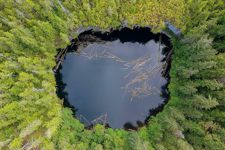
The star attraction of the Alice Lake Loop — a remote gravel road-accessed wilderness area between Port Alice and Port McNeill — the Devil’s Bath is reputed to be Canada’s largest cenote.
RELATED: Wrap up your summer on one of Vancouver Island’s best beaches
Associated mostly with Mexico’s Yucatan Peninsula, cenotes are essentially large, waterfilled sinkholes formed in limestone where cavern roofs collapse to form natural pools.
Port Alice landscape and wildlife photographer Douglas Bradshaw has taken some magnificent images of the Bath, which is 359 meters in diameter and 44 meters in depth.
“Last year I brought my drone to the cenote and photographed it from above. I think the view from above reveals a few details many may not know about,” he said. “Some of the trees near the water that have larger trees over top of them actually grow towards the reflection of the water in trying to gather more light.
“I like to walk down the trail towards the Benson River and check out the cave and river just below it. This trail is rough and should be executed with caution.”
According to sitesandtrailsBC.ca, the cenote connects to the Benson River, which is 200 metres to the northwest through a series of cave passages 80 metres below the water table. The cenote is a day-use recreation site not far off the ALice Lake road and has a viewing platform perched above which enables a great view into the dark waters below
The Alice Lake region is among the Island’s most notable examples of a landform known as karst. Named for a region in Europe’s Balkans where it was first studied, karst is a landscape largely formed by water action in soluble bedrocks, notably gypsum and carbonates such as limestone and marble.
Bradshaw travelled the Alice Lake Loop in July and reports the road had been recently graded.
“Now is a great time to check out Devils Bath and the many other scenic sites along the route,” he said.
RELATED: Winter Harbour: survival on edge of Vancouver Island
According to the vancouverislandnorth.ca tourism website, a full-loop circuit of the the Alice Lake loop takes approximately 2.5 hours. The Devil’s Bath and The Eternal Fountain — a nearby waterfall that appears out a rocky ledge and disappears into the ground below, and conceals a fascinating cave system — are both relatively close to the Port Alice end of the loop.
The feature karst sites have lots to explore and short hiking trails so make sure you give yourself enough time to explore.
— with a file from Tyson Whitney