A wildfire near Nanaimo is being used as a model to help a B.C. technology firm develop new technology to develop faster and more accurate ways of assessing wildfire spread and damage.
North Vancouver-based Hatfield Consultants is an environment assessment and monitoring company that works with private and government clients around the world.
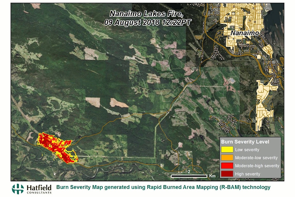
The company is currently gathering satellite data from B.C.’s wildfires to create animated maps of fire spread and burn severity. On Sunday, the Nanaimo Lakes fire was first detected by thermal sensors aboard NASA MODIS satellite, which prompted Hatfield to start gathering infrared images from the European Space Agency’s Copernicus Sentinel-2 satellites and begin running the image data through Hatfield’s R-BAM, Rapid Burn Area Mapping, technology to map the progression and intensity of the fire.
Andy Dean, Hatfield senior geomatics specialist, said the Nanaimo Lakes fire gave Hatfield a local example of a wildfire to work with.
“That’s one of the reasons why we did it,” Dean said. “It’s close to home for us, right, as well, so we’ll do a few fires in other parts of the province, but it’s close to home so we thought we’d take a look at it.”
Satellite infrared imaging can provide more accurate information about the extent of a fire than aerial observations because infrared imaging systems can penetrate smoke layers. R-BAM technology takes that information to produce accurate animated high-resolution maps of fire growth and how severely areas within the fire area are burned. Dean said the technology is being further developed to combine infrared data with radar data to also conduct fire mapping through heavy cloud cover, which attenuates the effectiveness of infrared.
Dean said the company worked with B.C. Wildfire last year using its technology to assess the after effect of wildfires – it also examined the Fort McMurray, Alta., fire – to study how to would best apply resources to help recover burned forests.
“It was for post-recovery planning,” Dean said. “What we’ve done recently is we’ve improved the capability to process the data very quickly, so now it’s about one hour from the time we get a satellite image, so now we’re contacting and approaching – as this wildfire season is suddenly become worse – the different agencies to let them know that we’ve got this capability.”
Hatfield has produced a map of the Nanaimo Lakes fire showing its spread since and what areas were most severely burned.
“In any emergency response situation, if you can provide the decision makers with high quality information in a timely manner, then it can support them to make good decisions in the field in terms of the response,” Dean said. “Not to say that this is yet something that they would be applying operationally in the field. We’re still developing and testing it, but we wanted to let people see the capabilities and kind of information that can be produced now, but I think first responders need to take a very close look at integrating any new technology into their emergency response capabilities, so I hope this is something that they’ll take a look at.”